Galapagos Islands
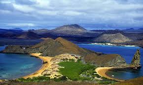 The Galápagos Islands are an archipelago of volcanic islands distributed on either side of the Equator in the Pacific Ocean, 926 km (575 mi) west of continental Ecuador, of which they are a part. The islands are found at the coordinates 1°40′N–1°36′S, 89°16′–92°01′W. Straddling the equator, islands in the chain are located in both the northern and southern hemispheres, with Volcán Wolf and Volcán Ecuador on Isla Isabela being directly on the equator.Española Island, the southernmost islet of the archipelago, and Darwin Island, the northernmost one, are spread out over a distance of 220 km (137 mi). The International Hydrographic Organization (IHO) considers them wholly within the South Pacific Ocean, however. The Galápagos Archipelago consists of 7,880 km2 (3,040 sq mi) of land spread over 45,000 km2 (17,000 sq mi) of ocean. The largest of the islands, Isabela, measures 2,250 sq mi/5,827 km2 and makes up close to three-quarters of the total land area of the Galápagos. Volcán Wolf on Isabela is the highest point, with an elevation of 1,707 m (5,600 ft) above sea level.
 The group consists of 18 main islands, 3 smaller islands, and 107 rocks and islets. The islands are located at the Galapagos Triple Junction. The archipelago is located on the Nazca Plate (a tectonic plate), which is moving east/southeast, diving under the South American Plate at a rate of about 2.5 inches (6.4 cm) per year. It is also atop the Galapagos hotspot, a place where the Earth’s crust is being melted from below by a mantle plume, creating volcanoes. The first islands formed here at least 8 million and possibly up to 90 million years ago.
Although located on the Equator, the Humboldt Current brings cold water to the islands, causing frequent drizzles during most of the year. The weather is periodically influenced by the El Niño events, which occur about every 3–7 years and are characterized by warm sea surface temperatures, a rise in sea level, greater wave action, and a depletion of nutrients in the water.[9]
During the season known as the garua (June to November), the temperature by the sea is 22 °C (72 °F), a steady and cold wind blows from south and southeast, frequent drizzles (garuas) last most of the day, and dense fog conceals the islands. During the warm season (December to May), the average sea and air temperature rises to 25 °C (77 °F), there is no wind at all, there are sporadic, though strong, rains and the sun shines.
European discovery of the Galápagos Islands occurred when Spaniard Fray Tomás de Berlanga, the fourth Bishop of Panama, sailed toPeru to settle a dispute between Francisco Pizarro and his lieutenants. De Berlanga’s vessel drifted off course when the winds diminished, and his party reached the islands on 10 March 1535. According to a 1952 study by Thor Heyerdahl and Arne Skjølsvold, remains of potsherds and other artifacts from several sites on the islands suggest visitation by South American peoples prior to the arrival of the Spanish. However, no remains of graves, ceremonial vessels and constructions have ever been found, suggesting no permanent settlement occurred at the time.
The group consists of 18 main islands, 3 smaller islands, and 107 rocks and islets. The islands are located at the Galapagos Triple Junction. The archipelago is located on the Nazca Plate (a tectonic plate), which is moving east/southeast, diving under the South American Plate at a rate of about 2.5 inches (6.4 cm) per year. It is also atop the Galapagos hotspot, a place where the Earth’s crust is being melted from below by a mantle plume, creating volcanoes. The first islands formed here at least 8 million and possibly up to 90 million years ago.
Although located on the Equator, the Humboldt Current brings cold water to the islands, causing frequent drizzles during most of the year. The weather is periodically influenced by the El Niño events, which occur about every 3–7 years and are characterized by warm sea surface temperatures, a rise in sea level, greater wave action, and a depletion of nutrients in the water.[9]
During the season known as the garua (June to November), the temperature by the sea is 22 °C (72 °F), a steady and cold wind blows from south and southeast, frequent drizzles (garuas) last most of the day, and dense fog conceals the islands. During the warm season (December to May), the average sea and air temperature rises to 25 °C (77 °F), there is no wind at all, there are sporadic, though strong, rains and the sun shines.
European discovery of the Galápagos Islands occurred when Spaniard Fray Tomás de Berlanga, the fourth Bishop of Panama, sailed toPeru to settle a dispute between Francisco Pizarro and his lieutenants. De Berlanga’s vessel drifted off course when the winds diminished, and his party reached the islands on 10 March 1535. According to a 1952 study by Thor Heyerdahl and Arne Skjølsvold, remains of potsherds and other artifacts from several sites on the islands suggest visitation by South American peoples prior to the arrival of the Spanish. However, no remains of graves, ceremonial vessels and constructions have ever been found, suggesting no permanent settlement occurred at the time.

Комментариев нет:
Отправить комментарий